The World Meteorological Organisation (WMO) has increased its El Niño likelihood forecasting, saying there’s an 80% likelihood that the weather phenomenon will hit this month and could last until November.
To what strength it would have is more unclear, though there seems to be consensus that it would range from at least moderate to strong.
Pouring fuel on the fire of a warming world
The United Nations (UN)’s weather agency urges the world to treat the arrival of El Niño as an urgent climate warning. It will pour fuel on the fire of a warming world, exacerbating the already severe climate impacts across the globe.
The impacts that El Niño will cause will hit even harder and travel even farther, and cross borders with devastating speed, the WMO explains.
The head of the UN, Secretary-General, António Guterres, repeated the warning stating:
“The only effective response is climate action equal to the crisis – ending the addiction to fossil fuels, accelerating the shift to renewables, protecting the most vulnerable, and delivering early warning systems for all.”
Indicators nearing El Niño conditions
Data shows that between late April and mid-May, the sea surface temperature in the central-eastern Equatorial Pacific, the area used as a monitoring reference, approached El Niño thresholds.
The WMO say that these surface anomalies are being fed by unusually warm subsurface conditions across the tropical Pacific, as temperatures exceeded 6 degrees C above average and created a substantial heat reserve that is a key contributor to the observed surface warming.
Another key indicator, the Southern Oscillation Index, the atmospheric component of El Niño, is also showing consistent conditions for the development of the weather phenomenon.
El Niño events typically occur every two to seven months and last around nine to 12 months. It normally starts developing between March and June and reaches peak intensity between November and February. The impacts it has on global temperatures are typically most predominant in the second year after development.
El Niño to exacerbate drought and heavy rainfall
“We need to prepare for a potentially strong El Niño event, which will exacerbate drought and heavy rainfall and increase the risk of heatwaves both on land and in the ocean. The most recent El Niño, in 2023-24, was one of the five strongest on record, and it played a role in the record global temperatures we saw in 2024,” WMO Secretary-General Celeste Saulo explained.
The impacts of El Niño vary greatly depending on its intensity, when it develops and reaches peak intensity and how it interacts with climate variability modes. It does not impact all regions on the planet, and even within a region, the impacts can be different.
Even a moderate El Niño makes weather and climate extremes more likely.
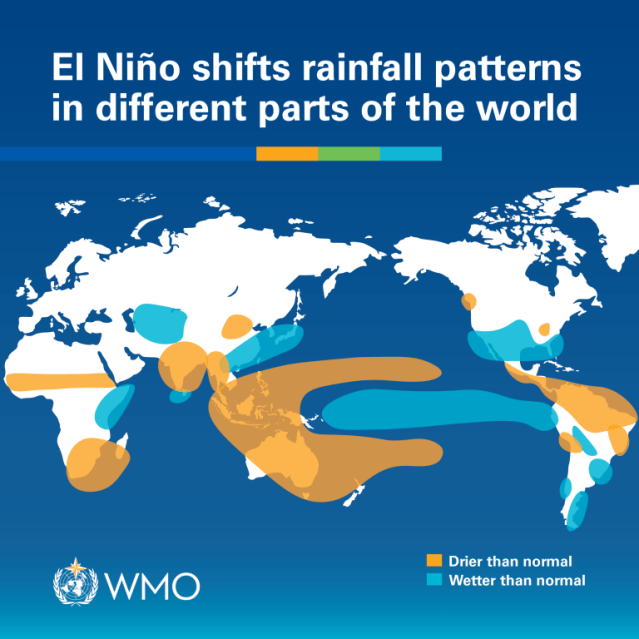
It normally influences increased rainfall in parts of South America, the southern US, parts of the Horn of Africa and central Asia and causes drier conditions across Central America, the northern part of South America, the Caribbean, Indonesia and parts of southern Asia.
During the Northern Hemisphere summer, the warm water of El Niño can also fuel hurricanes in the central and eastern Pacific Ocean, but weaken hurricane formation in the Atlantic Basin.
Anders Lorenzen is the founding Editor of A greener life, a greener world.
Discover more from A greener life, a greener world
Subscribe to get the latest posts sent to your email.
Categories: climate change, impacts, Weather
