Last updated: 10 August 2026
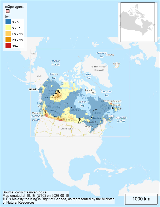
This data page tracks wildfire activity with the latest available data on active wildfires, fire danger, burned area, climate conditions and weekly trends. It is being developed as the home of A greener life, a greener world’s global wildfire monitor, with regional and national datasets being added progressively.
Canada at a glance
Last updated: 10 August 2026
National statistics: latest available CIFFC data from 29 July 2026. Provincial and territorial information may be more recent.
| Indicator | Figure | Date/source |
|---|---|---|
| Active wildfires in Canada | 888 | 29 July |
| Current largest fire | Pear Lake — approximately 126,876 ha | 7 August |
| Wildfires recorded in 2026 | 4,243 | 29 July |
| Area burned in 2026 | 3,755,774 ha | 29 July |
| National preparedness level | Level 4 | 29 July |
| Current regional hotspot | British Columbia (BC) | 9 August |
| BC active wildfires | 102 | 9 August |
| BC provincial emergency | Declared | 8 August |
| National wildfire trend | Increasing | Latest national assessment |
Major active wildfires
Last updated: 10 August 2026
| Wildfire | Province/territory | Approx. size | Status |
|---|---|---|---|
| Bald Range | British Columbia | >10,000 ha | Out of control |
| Wood Buffalo fire 2026WB004 | Northwest Territories | 46,674 ha | Out of control |
| Wood Buffalo fire 2026WB008 | Northwest Territories | 338 ha | Out of control |
| Wood Buffalo fire 2026WB007 | Northwest Territories | 38 ha | Out of control |
| … | … | … | … |
Weekly overview
Last updated: 10 August 2026
Canada’s wildfire situation has deteriorated significantly since the federal government’s July assessment. The most acute escalation is currently in British Columbia, where more than 100 wildfires are active and a province-wide state of emergency was declared on 8 August.
The Bald Range wildfire has grown to more than 10,000 hectares and triggered large-scale evacuations around Summerland and Peachland. Federal assistance has now been requested to support people displaced by the fires.
The Canadian wildfire situation remains highly dynamic, and national statistics may lag the latest provincial and territorial reports.
Explore our European wildfire data below:
Methodology – Canadian wildfire data
Canadian wildfire data are compiled from national, provincial, territorial and federal fire-management sources.
National statistics shown above are the latest verified CIFFC figures available to us, dated 29 July 2026. The CWFIS national system is intended to provide more frequent updates, while individual provincial and territorial agencies may provide more recent information on active fires.
The Canadian Interagency Forest Fire Centre (CIFFC) provides national wildfire statistics, including active-fire numbers, fires recorded during the year, area burned and national preparedness information.
The Canadian Wildland Fire Information System (CWFIS), operated by Natural Resources Canada, provides national wildfire information including reported active fires, fire danger and supporting fire-weather and fire-monitoring data.
Individual wildfire information is supplemented by provincial and territorial wildfire agencies and Parks Canada, particularly where more recent information is available for individual fires.
Because wildfire reporting systems operate at different frequencies, national statistics and individual fire information may have different update dates. All figures on this page are therefore dated to indicate when they were last verified.
Data note about the Canadian wildfire data:
National wildfire statistics are compiled from Canadian Interagency Forest Fire Centre and Canadian Wildland Fire Information System data. National figures may lag individual provincial and territorial updates. Individual wildfire information is sourced from the relevant fire-management agency. Figures are dated to indicate when they were last verified.
Methodology – European wildfire data
European wildfire data are compiled from the European Forest Fire Information System (EFFIS), Copernicus Emergency Management Service, Copernicus Atmosphere Monitoring Service (CAMS), NASA FIRMS and national civil protection and wildfire agencies.
The European dataset combines information on active major wildfires, fire danger, burned area and related wildfire conditions. National and regional agencies may provide more recent information for individual fires than the European-level datasets.
European wildfires data sources
European Forest Fire Information System (EFFIS), Copernicus Emergency Management Service, Copernicus Atmosphere Monitoring Service (CAMS), NASA FIRMS and National civil protection and wildfire agencies.
Why we are publishing this dataset
Wildfire seasons are becoming longer, more frequent and increasingly destructive in many parts of the world as climate change contributes to hotter and, in some regions, drier conditions.
This global wildfire monitor serves as the home of global wildfires data and from here you can visit regional, national and local wildfire data hubs alongside editorial analysis from A greener life, a greener world.
It is updated weekly throughout the wildfire season and provides an overview of:
- Active major wildfires
- Fire danger across Europe
- Burned area statistics
- Weekly wildfire trends
- Largest active fires
- Climate conditions driving wildfire activity
- Historical comparisons
You can see our other datasets here.
 A greener life, a greener world