Last updated: 10 August 2026
This data page tracks wildfire activity in British Columbia (BC), including active wildfires, fires by stage of control, major fires, evacuations and fire danger. It forms part of A greener life, a greener world’s global wildfire monitor, which is being developed progressively across regions, countries and sub-national jurisdictions.
We also provide rolling updates on the BC wildfire which can be assessed below:
Our wider Canadian wildfire monitor page can be explored below:
BC at a glance
Last updated: 10 August 2026
Wildfire activity figures: latest available BC Wildfire Service data. Individual figures may have different update dates because wildfire information changes rapidly and operational data are updated at different times.
| Indicator | Figure | Date/source |
|---|---|---|
| Active wildfires | 103 | 11 August |
| Out-of-control wildfires | 47 | 11 August |
| Wildfires being held | 27 | 11 August |
| Wildfires under control | 29 | 11 August |
| Wildfires of note | 4 | 11 August |
| Current largest fire | Pear Lake — approximately 147,677.17 ha | 10 August |
| Provincial state of emergency | Declared | 8 August |
| Evacuation orders | 32 | Latest BC Wildfire Service data |
| Evacuation alerts | 28 | Latest BC Wildfire Service data |
Data-date note: The BC Wildfire Service dashboard currently reports 139 active wildfires, including 56 out of control, 31 being held and 52 under control. Its accessible situation report is dated 26 July, while EmergencyInfoBC confirms that the provincial state of emergency and multiple wildfire evacuation notices remained active on 8–9 August. Figures should therefore be read alongside their individual source dates rather than as a single 10 August snapshot.
Wildfires of Note
Last updated: 10 August 2026
| Wildfire | Fire centre | Approx. size | Status | Current significance |
|---|---|---|---|---|
| Pear Lake | Cariboo | Approximately 147,677.17 ha | Wildfire of Note | Largest active fire; evacuation orders and alerts |
| Ainslie Creek | Coastal | Approximately 54,131.78 ha | Wildfire of Note | Major evacuations around Summerland and Peachland |
| Bald Range | Coastal | Approximately 15,590 ha | Wildfire of Note | Major evacuations around Summerland and Peachland |
| Brunswick Creek | Coastal | Approximately 8,802.5 | Wildfire of Note | Evacuation orders and alerts. |
Weekly overview
Last updated: 10 August 2026
BC is experiencing a major escalation in wildfire activity, with more than 100 active wildfires reported across the province and a provincial state of emergency declared on 8 August.
EmergencyInfoBC continues to list the state of provincial emergency as active, while multiple local authorities and First Nations have issued or updated wildfire evacuation information.
The most severe current situation is in the Okanagan, where the rapidly expanding Bald Range wildfire has triggered large-scale evacuations around Summerland and Peachland. The fire expanded to more than 100 square kilometres, while thousands of residents were evacuated from communities around Okanagan Lake. Federal assistance has been requested to support people displaced by the fires.
Pear Lake in the Cariboo Fire Centre remains one of the province’s largest active wildfires, with an estimated area just shy of 126,876 ha. The BC Wildfire Service classifies it as out of control and lists multiple evacuation orders and alerts associated with the incident.
Wildfire conditions remain highly dynamic. Fire perimeters, evacuation information and individual incident status can change rapidly, and the BC Wildfire Service cautions that its operational data should be treated as reference information rather than a guarantee of the current situation.
Wildfire map
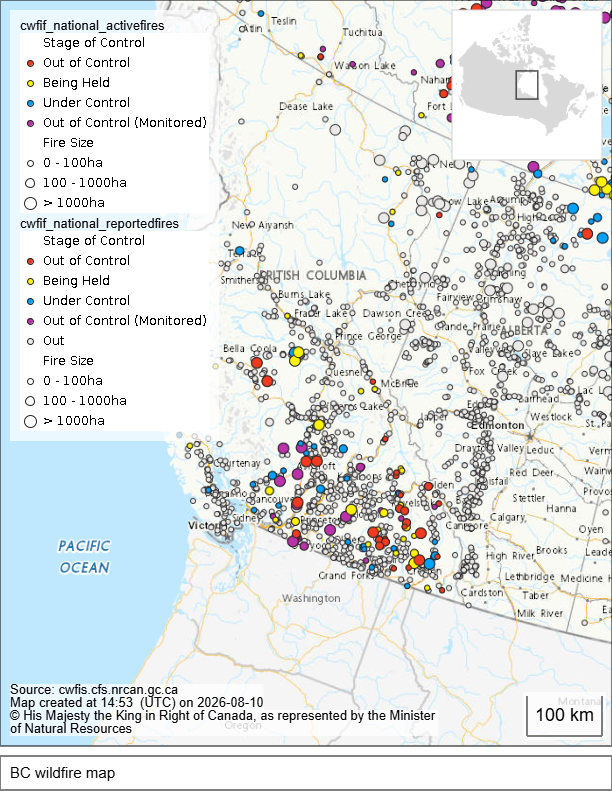
British Columbia wildfire map as of 10 August 2026.
Source: BC Wildfire Service, Province of British Columbia. Fire points, fire perimeters and related wildfire information are compiled from provincial operational systems and other sources. Data and incident information may change rapidly.
Data note about the BC wildfire data
Wildfire information is compiled primarily from the BC Wildfire Service and Province of British Columbia emergency-management sources.
The BC Wildfire Service provides information on active wildfires, wildfire status, fire perimeters, Wildfires of Note, evacuation information and fire danger. They state that individual wildfire data are updated when practicable and that operational fire-perimeter data may be refreshed from source systems every five minutes.
However, the frequency of individual incident updates varies and mapped fire perimeters may not represent the precise current extent or level of fire activity.
EmergencyInfoBC provides verified emergency information, including evacuation orders and alerts issued by local governments and First Nations.
Evacuation information is provided to the province by local governments and First Nations and may not always reflect the most recent local situation. Readers should consult the relevant local authority for the latest evacuation information.
Explore our European wildfire data below:
Methodology – BC wildfire data
The British Columbia tracker uses the following hierarchy of sources:
BC Wildfire Service is the primary source for active wildfire numbers, wildfire status, Wildfires of Note, fire-centre information, fire perimeters and fire-danger information.
EmergencyInfoBC is the primary provincial source for the state of emergency and verified evacuation orders and alerts.
Local governments and First Nations are used to verify individual evacuation information where more recent local updates are available.
The dashboard distinguishes between out of control, being held and under control fires according to BC Wildfire Service classifications.
A fire classified as out of control is not responding to suppression actions and is projected to spread beyond its current perimeter; fires being held or under control are subject to different levels of suppression effectiveness and expected behaviour.
Because wildfire information changes rapidly, individual indicators may have different verification dates. The dashboard therefore displays dates alongside figures wherever possible.
Data note about the BC wildfire data:
Wildfire information is compiled primarily from the BC Wildfire Service and Province of British Columbia emergency-management sources.
The BC Wildfire Service provides information on active wildfires, wildfire status, fire perimeters, Wildfires of Note, evacuation information and fire danger. EmergencyInfoBC provides verified emergency information, including evacuation orders and alerts issued by local governments and First Nations.
The BC Wildfire Service states that individual wildfire data are updated when practicable and that operational fire-perimeter data may be refreshed from source systems every five minutes. However, the frequency of individual incident updates varies and mapped fire perimeters may not represent the precise current extent or level of fire activity.
Evacuation information is provided to the Province by local governments and First Nations and may not always reflect the most recent local situation. Readers should consult the relevant local authority for the latest evacuation information.
Why we are publishing this dataset
BC is one of the world’s major wildfire regions and has experienced increasingly complex and severe wildfire seasons in recent years. Monitoring wildfire activity at provincial level provides a more detailed picture than national statistics alone and allows major incidents, evacuations and changes in fire behaviour to be tracked more closely.
This BC tracker forms part of A greener life, a greener world’s global wildfire monitor. It sits within the planned North American structure alongside the wider Canada tracker and will eventually be complemented by equivalent state- and province-level trackers across North America.
The wider wildfire monitor provides an overview of:
- Historical comparisons
- Active major wildfires
- Fire danger
- Burned area statistics
- Weekly wildfire trends
- Largest active fires
- Evacuations and emergency situations
- Climate and weather conditions influencing wildfire activity
You can see our other datasets here.
 A greener life, a greener world