 |
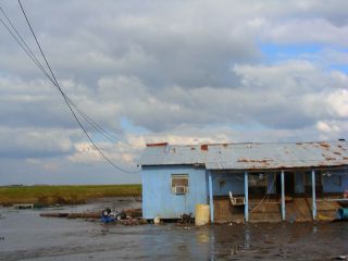
| Isle de Jean Charles. Source: Wikimedia. |
By Malee Oot
Southern Louisiana is disappearing fast. In the last century, the state has lost more than 1,900 square miles of coast – an area equivalent in size to the state of Delaware. As
global climate change continues to catalyze rising sea levels, and the
Gulf of Mexico swallows more and more ground every year, one of the Louisiana’s most resilient communities is watching the land they have inhabited for generations slip away forever – unable to save the island they cherish from the perpetually rising water.
The members of the
Biloxi-Chitimacha-Choctaw tribe of Isle de Jean Charles are now being called the America’s first official climate refugees. Located in Terrebonne Parish, about an 80-mile drive southwest of New Orleans, the swath of land known as Isle de Jean Charles has all but disappeared in the half century. Remembered by longtime residents as a place fringed with cypress groves, sprinkled with livestock pastures and clusters of live oaks and willow trees – the barrier island was once than 15,000 acres in area and as much as five miles wide – but since 1955 has lost 98 percent of its landmass. The ever encroaching water has now reduced Isle de Jean Charles to a finger of land merely a quarter of a mile wide and a half-mile long.
Google Map of Isle de Jean Charles.
Once claimed to be ‘uninhabitable swampland’ by the state of Louisiana, Isle de Jean Charles has been home to the Biloxi-Chitimacha-Choctaw for nearly 170 years – the earliest residents officially purchased land on the island when the state first opened the area to private buyers beginning in 1876. However, even after being settled by the tribe, for decades the wetland-fringed sweep of land was considered a remote place well enough left alone – in many ways isolated from the mainland –the first road to Isle de Jean Charles wasn’t even built until 1953.
Despite the tight knit sense of community and deeply entrenched attachment to their ancestral home, the rapidly deteriorating conditions on Isle de Jean Charles have already forced many residents to relocate – and with the land beneath them disappearing – those remaining on the island will soon have no choice but to do the same.
In late January, as part of a billion dollar
National Disaster Resilience Competition, Louisiana was awarded nearly $93 million from the Department of Housing and Urban Development (HUD) to devote to building climate resilience. A large segment of this HUD funding – about $48 million – is slated to be used to relocate the entire community of Isle de Jean Charles to higher ground – something the tribe’s chief, Albert Naquin, told
Indian Country Today he has been working towards for over a decade.
The HUD-provided resettlement fund not only enables the tribe to relocate to a more stable site, but more importantly, also allows the community to stay intact by resettling all of the island’s residents in a new home-site together – preventing tribe members from scattering across southern Louisiana or beyond in search of new homes.
While in the last two decades the situation on Isle de Jean Charles has become increasingly precarious, in the past relocation proposals have met with resistance as longtime residents raised concerns about what would happen to their land on the island — including in 2002, when the Army Corps of Engineers (ACE) offered to move the tribe after cost constraints stipulated a 72-mile levee constructed as part of the Morganza to the Gulf of Mexico Hurricane Protection Project be rerouted to exclude Isle de Jean Charles from the protected area. Under the new HUD proposed relocation plan, islanders will be able to retain ownership of their land on Isle de Jean Charles – even after they leave.
The rapidly rising water is just part of the problem.
The coast of Louisiana is regularly buffeted by intense tropical storms.
Hurricanes hit the state about every four years, on average, according to the
Union of Concerned Scientists. But, as the
barrier islands buffering the Louisiana mainland continue to disappear into the Gulf at an alarming rate – so rapidly, they could be gone completely by the end of this century, according to the U.S. Geological Survey (USGS) – coastal communities are left even more vulnerable to
extreme weather events, like hurricanes and tropical storms.
In the 2012 environmental film
Last Stand on the Island, documenting the history of the Biloxi-Chitimacha-Choctaw, longtime residents of Isle de Jean Charles have also reported coastal storms are coming more frequently — beginning with Hurricane Andrew, in 1992, at the time the most destructive storm to ever hit the U.S. coast. Then, just a decade later, in 2002, came Hurricane Lilli — and after Lilli, they just kept coming, and the island was pummeled by a storm every two or three years.
But the story of the disappearance of Isle de Jean Charles isn’t just a matter of
rising water and surging superstorms — there is another major piece — a part of the larger history of coastal Louisiana, a legacy of shortsighted and catastrophic environmental mismanagement driven by oil and gas interests.
Before the arrival of Europeans, the coast of Louisiana was a vast and enormously productive wetland ecosystem – nearly 6,000 square miles in area – according to the 2014
ProPublica report Losing Ground. Despite the biodiversity of these ecosystems, for decades, the swamps and marshes of southern Louisiana – places like Isle de Jean Charles – were considered nothing more than mosquito plagued backwaters, certainly of little value.
But, everything changed in the 1930s when bountiful deposits of gas and oil were found beneath the wetlands of southern Louisiana. The emerging
energy industry was only too eager to exploit these areas once considered worthless. Oil and gas companies began to ravage Louisiana’s coastal swamps and marshes, expanding natural waterways and hauling in manpower and heavy machinery. Nearly 10,000 miles of canals were carved out the state’s coastal wetlands – serving some 50,000 wells – according to ProPublica. The situation deteriorated further nearly 75 years ago when the states’s oil and gas industries moved further offshore – wetlands were again torn apart – this time, for the construction of miles and miles of pipelines.
In the last two decades, almost of half of
America’s wetlands have disappeared, according to the U.S. Geological Survey (USGS) — and in southern Louisiana, the very area disappearing is also responsible for providing nearly a third of the country’s total oil and gas supply, according to ProPublica.
Around Isle de Jean Charles, the
oil companies first starting appearing in the early 1950s — and didn’t any waste time slicing canals through the freshwater marsh bordering the island. As oil and gas companies hacked away at the wetlands, more and more saltwater began to creep in – first killing off the trees anchoring the island’s terrestrial habitat – and slowly, causing more and more land to erode. Each time a storm pounded the island, more and more of Isle de Jean Charles slipped into the Gulf.
Meanwhile, during the first half of the 20th century, while oil and gas companies were ravenously hacking up coastal Louisiana’s wetlands, the region’s lifeblood — the mighty Mississippi River – the waterway responsible for not only replenishing the delta wetlands, but also, for spreading the sediment and detritus essential for building up coastal landmasses, was undergoing dangerous alterations of its own, also in the name of progress.
 |
| Aerial photo of the Mississippi River Delta. Photo credit:U.S. Geological Survey via Flickr. |
Even in its infancy, during the first quarter of the 18th century, the residents of New Orleans were building levees to protect the burgeoning city from the Mississippi. Throughout the 19th century, the construction of levees was the prevailing method of flood control used in the United States – and with the Mississippi restrained with flood-preventing-levees, the natural flooding cycles vital for replenishing the delta was slowly being choked and reshaped to protect ever-spreading human development.
At the nexus of these tumultuous forces – continually rising sea levels and a legacy of catastrophic environmental mismanagement – are the small, and now quickly disappearing, coastal communities like Biloxi-Chitimacha-Choctaw — and in Louisiana, barrier islands like Isle de Jean Charles are the canaries in the coalmine, the harbingers of things to come.
And it’s not just Louisiana. Across the United States an entirely new type of refugee crisis is beginning to emerge– from the Pacific Northwest to the Chesapeake Bay – coastal communities around the country are facing the same fate as the people of Isle de Jean Charles. In northern Washington, the Quinault Indian Nation has developed a $60 million proposal to relocate the village of Taholah to higher ground, away from the reach of the swelling Pacific Ocean. The state of
Alaska also bid for a segment of the HUD funding awarded as part of the National Disaster Resilience Competition, requesting federal assistance to relocate the Yup’ik Eskimo village of Newtok on the Bering Sea, which could be underwater by next year, according to the Army Corps of Engineers.
According to the 2014
National Climate Assessment, the impacts of global climate change are projected to be especially severe for tribal and indigenous groups throughout the United States, exacerbated by the socioeconomic challenges also facing many of the country’s Native American communities.
The HUD-funded relocation of the people of Isle de Jean Charles – conducted in partnership with the non-profit
Lowlander Center – is something of a pilot project, the first undertaking of its kind. According to a
press release from the Lowlander Center, ‘The
resettlement will become a living model of community cultural resilience, disaster and climate change mitigation, green building, environmental stewardship, and sustainable economic development’.
Even despite the nearly two decade push to relocate the people of Isle de Jean Charles to safety, the HUD relocation is bittersweet – and as other native communities around the country struggle with the potentially similar fate – the Biloxi-Chitimacha-Choctaw hope to be a resource for others similarly facing the climate-trigged loss of their longtime home.
‘Maybe we can be the model community to teach others,’ Chief Albert Naquin told Indian Country Today.
Malee is a freelance writer with a background in environmental management. She has lived in Kenya, Nepal, Thailand, and the United Kingdom and is currently based in Washington, DC.
Discover more from A greener life, a greener world
Subscribe to get the latest posts sent to your email.


3 replies »