 |
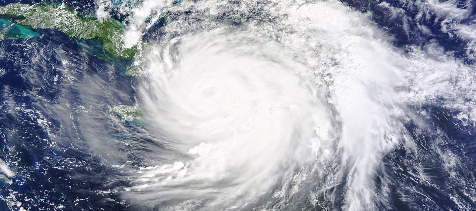
| Hurricane Matthew. Photo credit: NASA. |
Editorial note: Hurricane Matthew, which has already left it’s devastating mark on Haiti is set to be the first category 5 Hurricane to hit since 2007 and is set to hit the US coast on Friday morning and could make landfall.
By Astrid Caldas
It is hard to pull one’s eyes away from the images of Haiti in the aftermath of Hurricane Matthew. If one needed proof that we live in an indifferent universe, that broken land and its suffering people caught in a new, unfolding catastrophe should suffice.
But even as we watch disaster grip Haiti, reports are beginning to flow of a potential U.S. East Coast landfall and mandatory evacuations. Our coastal communities, while so well-resourced and resilient in comparison to Haiti, are still woefully unprepared for major storms. They now need to mobilise for Hurricane Matthew.
Hurricanes are getting increasingly destructive
Through the fog of presidential politics that has enveloped the media, news of this storm is beginning to reach people and disrupt lives and plans. I for one was at the airport, ready to board a flight to Florida to participate in a climate conference when I received the news that the conference was likely going to be canceled, and that I should not travel. This is how fast this storm developed.
Matthew turned from a tropical storm into a Category 5 hurricane in just 36 hours, mainly fueled by warmer than average waters. According to Climate Signals, as of October 3, Matthew was the longest-lived Category 4-5 hurricane and had generated the most Accumulated Cyclone Energy (orACE, a measurement that expresses the activity and destructive potential of individual tropical cyclones and entire tropical cyclone seasons) in the eastern Caribbean of any Atlantic hurricane on record.
More powerful hurricanes are not a surprise, given global warming and other factors, and recent research in this area suggests that hurricanes in the North Atlantic region have been intensifying over the past 40 years (learn more in this comprehensive review of hurricane trends and what influences them).
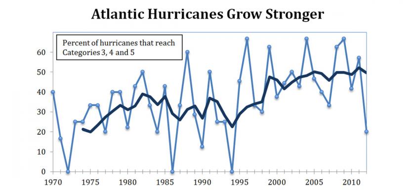
Percent of Atlantic hurricanes each year from 1970 to 2012 that reached categories 3, 4, and 5. Annual data (light blue) and 5-year running average (dark blue). Graphic: Union of Concerned Scientists
Impacts of disasters fall disproportionately on the world’s poor and vulnerable communities
This is particularly true of disasters with climate connections.
Matthew may end up dumping as much as 40 inches of rain in Haiti and the Dominican Republic, whipping the country with sustained winds of 145 mph (the average annual rainfall in Port-au-Prince is 33.68 inches). Already reports are coming in of the devastation it is bringing to those nations.
Cuba is also on high alert, and a 10 to 15-foot storm surge is expected in the Bahamas, where the average elevation appears to be less than 15 feet.
The impacts from Matthew will be felt by wealthy and poor communities alike, but the latter usually are not well prepared and lack the resources to rebound and get back on their feet in a timely or comprehensive manner. And this is not true only of foreign nations: many communities along the US coast find themselves in the same situation.
Florida has a whole generation of people who have not witnessed a major hurricane
Such a powerful hurricane brings rain and storm surge that can be life-threatening, as we have already seen in Haiti. With each recent update, the track of the now Category 4 hurricane has moved farther west, and closer to the US East Coast.
Right now, Matthew is on track to skim very close to the Florida coast from late Thursday, October 6 through Friday, October 7. By Saturday, October 8, the storm will begin impacting Georgia and the Carolinas. In the Southeast, some evacuation orders have already been issued.
This is a gravely serious storm, the likes of which states like Florida have not seen in a generation. Indeed, since Hurricane Andrew, in 1992, millions of people have taken up residence along the Florida coast.
Most of today’s East Coast residents have never experienced a hurricane of this magnitude and power, nor much considered the risks. And they now have a matter of hours to prepare.
Here I will focus on what we need to know to weather this storm. In subsequent posts, we will address what can be learned in its aftermath.
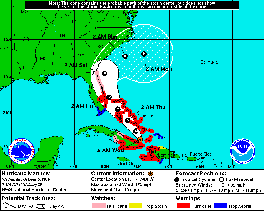
Tracking Hurricane Matthew. National Hurricane Center forecast, October 5.
Preparedness is essential and must be taken seriously
A storm moving along the Atlantic can have a variety of impacts. Such a powerful hurricane brings rain and storm surge that can be life-threatening. For Matthew, the most up-to-date predictions are:
-
Storm surge will build as the hurricane approaches land and drives water ashore. Forecasts are still preliminary given the uncertainty of the precise storm track but suggest that coastal areas in Florida, Georgia, and the Carolinas will see flooding greater than 1 foot and greater than 3 feet in some places. Check here for the latest updates and forecasts.
-
There is currently up to a 30 percent probability of 74 mph or higher surface winds in Florida, and winds of 50-60 mph with gusts up to 70-85 mph in North Carolina, with storm surge potentially as high as 4 feet.
For those beginning to wonder what this storm may mean for them, UCS has compiled a set of resources not only for the US but for the other affected nations:
-
NOAA/NWS storm tracking page.
-
First Coast News evacuation notices page.
-
Florida Emergency Management Disaster emergency planning page.
-
How to help Caribbean nations.
In the US, September was National Preparedness Month and the administration took that opportunity to release four new actions to increase our nation’s resilience (Leveraging Data, National Security, Building Community Capacity, and Smart Cities Initiative).
Matthew reminds us, however, that we need to continue to talk about climate, and not only our country’s disaster policy shortcomings but also (and importantly) the impacts of on the world’s poor and vulnerable communities.
First published on the Union of Concerned Scientists.
Astrid Caldas is a climate scientist with the Climate & Energy program at the Union of Concerned Scientists.
Discover more from A greener life, a greener world
Subscribe to get the latest posts sent to your email.
Categories: Carribean, category 5, climate impacts, Extreme weather, Haiti, Hurricane Matthew

6 replies »